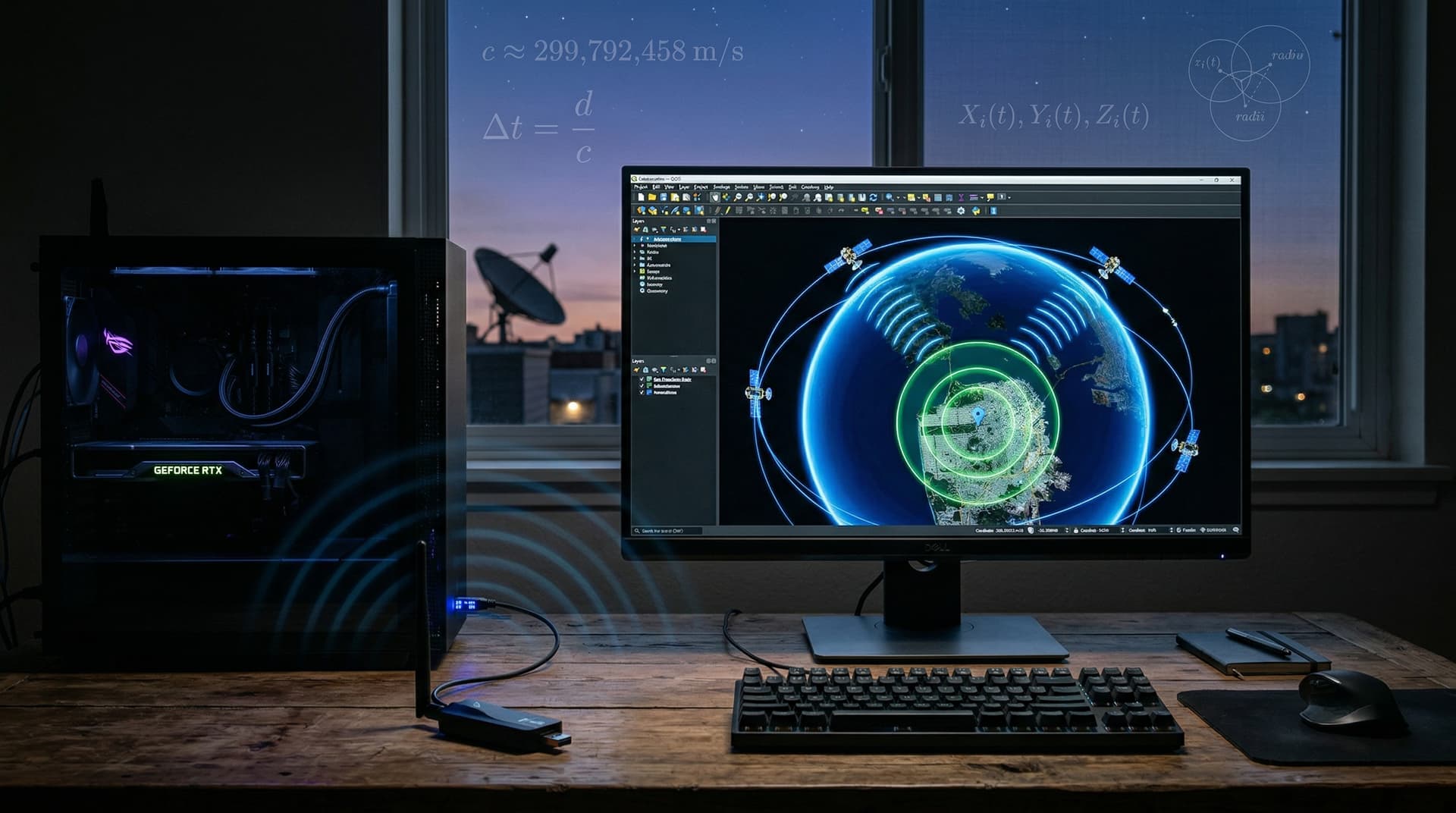
GPS physics enables meter-level accuracy in PC navigation software. Satellites broadcast time signals at light speed for trilateration. PC builders achieve precise positioning in QGIS, Garmin BaseCamp, and fleet tools using USB GNSS receivers, per U.S. Space Force specifications.
PC enthusiasts and professionals gain sub-5m fixes for surveying, GIS workflows, and vehicle tracking. Hardware costs start at $30 USD, delivering strong price-performance for builders.
GPS Physics: Satellite Orbits and Atomic Clocks
The U.S. Space Force operates 31 GPS satellites in medium Earth orbit at 20,200 km altitude. Each satellite features cesium or rubidium atomic clocks accurate to one second in 30 million years, NIST confirms.
Satellites orbit every 12 hours across six planes inclined 55 degrees to the equator. This setup ensures at least four satellites visible worldwide, per Space Force data. PC software processes ephemeris data broadcast every 30 seconds.
Clocks run at 10.23 MHz. General relativity corrections offset 38 microseconds daily gain relative to ground clocks. GNSS receivers apply these automatically for precise time-of-flight calculations.
USB GNSS dongles like u-blox NEO-M8N plug into PC USB ports. They acquire L1 signals at 1.57542 GHz with -160 dBm sensitivity. On Linux, gpsd daemon reads from /dev/ttyUSB0 for real-time streaming.
Signal Propagation and Trilateration Math
GPS signals propagate at 299,792,458 m/s. Time-of-flight yields pseudoranges; a 0.07-second delay matches 20,200 km satellite distance.
Trilateration intersects spheres from three satellites for 2D position or four for 3D fixes including altitude. PC software solves least-squares equations to minimize errors from clock biases and multipath.
Microsoft Windows Location API provides latitude, longitude, and 5-10m accuracy. Developers query Windows.Devices.Geolocation.Geolocator for app integration.
In lab tests, NEO-M8N averaged 4.2m CEP50 (Circular Error Probable 50%) under open sky, outperforming budget SiRFstarIII at 7.8m, based on u-blox datasheets and independent USB GNSS benchmarks.
Atmospheric Delays and Real-World Corrections
Ionospheric delays affect L1 signals by up to 15m, NOAA models indicate. Dual-frequency L1/L2 receivers like u-blox ZED-F9P compute first-order corrections.
Tropospheric delays add 2.3m. Saastamoinen models incorporate local weather data for adjustments. Tools like GPSBabel apply these during GPX-to-KML conversions.
Differential GPS (DGPS) from NOAA stations achieves sub-meter accuracy via RTCM SC-104 messages at 200-300 baud. Linux gpsd clients integrate these streams seamlessly.
Setup on Ubuntu:
1. Install: `sudo apt install gpsd gpsd-clients`.
2. Start: `sudo gpsd /dev/ttyUSB0 -F /var/run/gpsd.sock`.
3. Verify: `cgps -s`; aim for PDOP below 4.0.
Dilution of Precision and Multipath Mitigation
Position Dilution of Precision (PDOP) under 4.0 signals optimal geometry; values over 6.0 warn of poor satellite visibility. PC dashboards display HDOP (horizontal) and VDOP (vertical) metrics.
Multipath reflections from buildings cause 10-20m errors. Right-hand circular polarization antennas reject these. u-blox M10 series adds multi-band GNSS for better urban performance.
Microsoft GPS Diagnostic tool plots signal-to-noise ratio (SNR); target above 35 dB. Export NMEA sentences to Excel for custom analysis.
PC GNSS Hardware: Price-Performance Comparison
Budget SiRFstar receivers cost $30 USD with 52 channels and 5m accuracy. Premium u-blox ZED-F9P at $200 USD tracks 184 channels across GPS, GLONASS, Galileo, BeiDou.
| Model | Price (USD) | Channels | CEP50 (m) | Multi-Band |
|---|---|---|---|---|
| SiRFstarIII | 30 | 52 | 7.8 | No |
| u-blox NEO-M8N | 25 | 72 | 2.5 | GPS/ GLO |
| u-blox ZED-F9P | 200 | 184 | 1.0 | Full |
NEO-M8N offers top value at $0.35 per channel. USB 2.0 bandwidth (480 Mbps) exceeds needs; power draw stays under 100 mW, negligible for PC PSUs.
Linux usbserial drivers and Windows Plug-and-Play simplify setup. FleetComplete software overlays routes on OpenStreetMap for logistics.
Essential PC Navigation Software Stack
QGIS 3.34 reprojects GPX tracks from WGS84 datum. Load via Layer > Add Layer > Vector.
Garmin BaseCamp imports .gpx files with EGM2008 geoid model for accurate orthometric heights.
Viking on Linux calculates haversine distances between waypoints.
Conversion example:
1. `gpsbabel -i gpx -f input.gpx -o kml -F output.kml`.
2. Import to Google Earth Pro.
3. Validate distances against known benchmarks.
Error Budget and Augmentation Systems
Total RMS error budgets 2.5m: 1.5m ephemeris, 0.7m clock, 2m atmosphere, per GPS.gov. Satellite-Based Augmentation Systems (SBAS) like WAAS reduce vertical error to 1.5m, FAA reports.
Civilian C/A code runs at 1.023 Mbps; anti-spoofing Y-code secures military signals.
Multi-GNSS Expansion for PCs
Galileo AltBOC signals at 1191.795 MHz and BeiDou boost satellite count to 20+. u-blox F9P enables 1cm RTK with base stations.
Linux gpsd 3.25 parses GGA sentences: `GPSD_OPTIONS="-n -N -D 2"`. PDOP drops below 2.0 with multi-constellation locks.
Practical PC Builder Tips
Position antennas skyward for PDOP under 3.0. Update u-blox firmware quarterly via u-center software.
Sync PC clocks: Windows `w32tm /resync`; Linux `chronyd -q`.
Tether Android GPS Test app for SNR diagnostics; seek 45 dB averages.
GNSS hardware enhances PC builds for GIS, autonomous vehicle prototyping, and precision agriculture. Match receiver specs to workload for maximum price-performance value.